IMPACT OF LAND USE CHANGES ON FLOOD RISK AND WATER SUPPLY
Abstract
This article describes the impact of land use changes within the Iška River catchment, due to natural or anthropogenic factors, on surface runoff and groundwater status, and consequently on flood risk along the Iška River. Additionally, the impact on the lowering of groundwater level around the water supply facility Brest and its wells, and thus on the functioning of the water supply system, supplying drinking water to Ig and Ljubljana, is presented. The impact of changes in land use and forest overgrowth within the catchment on flood risk and on the connections between surface water and groundwater, which enable the functioning of the water supply facility Brest, were analysed by a combination of hydrological, hydraulic and hydrogeological modelling. Twentyseven scenarios were examined, which, in addition to land use changes, included different precipitation events, climate change scenarios, natural hazards (ice storms, bark beetles), and human interventions (afforestation). The consequences of natural or anthropogenic land use changes can be limited, to some extent, by mitigation measures. However, it should be noted that in the areas protected by the legal regime, restrictions, prohibitions and rules apply that also affect remedial measures. Therefore, the water flow must be followed. For the individual processes, the source and the level of risk under normal and emergency conditions must be evaluated.
Downloads
References
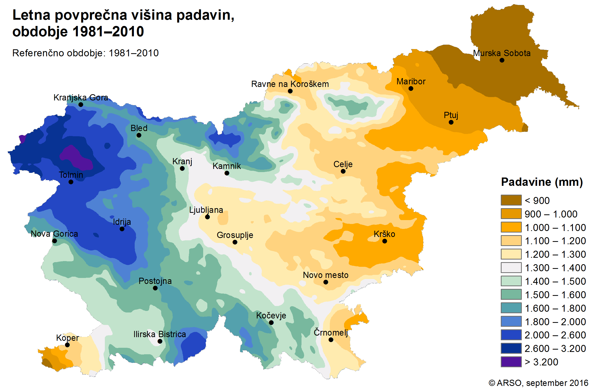
ARSO, 2016. Povprečna letna višina merjenih padavin (1981–2010). https://meteo.arso.gov.si/uploads/probase/www/climate/image/sl/by_variable/precipitation/mean-annual-measured-precipitation_81-10.png. (10. 10. 2017).
ARSO, 2018. Ocena podnebnih sprememb v Sloveniji do konca 21. stoletja. https://meteo.arso.gov.si/uploads/probase/www/climate/text/sl/publications/OPS21_Porocilo.pdf. (12. 3. 2019).
EEA, 2010. Strategija EU za Podonavje. https://ec.europa.eu/regional_policy/sl/information/publications/factsheets/2017/factsheet-eu-strategy-for-the-danube-region. (December 2018).
Golob, A., Polajnar, J., 2015. Visoke vode v Sloveniji leta 2014. Ujma 29, 62–65.
HEC, Hydrologic Engineering Center, US Army Corps of Engineers; 2018. HEC-RAS, River Analysis System, 2D Modeling User´s Manual, Version 5.0. Davis, CA: 171 str.
JP VOKA SNAGA, 2014. Ilustracije vodarn Kleče in Brest. Ljubljana, JP VOKA. https://www.vokasnaga.si/aktualno/ilustracije-vodarn-klece-brest.
Lapanje, A., Meglič, P., Mali, N., Jež, J., Novak, M., Jamšek Rupnik, P., Atanackov, J., Celarc, B., 2014. Izdelava metodologije in pilotnega vnosa hidrogeološke karte M 1: 25.000. Zvezek 4, Tolmač hidrogeološke karte pilotnega območja Iškega vršaja. Ljubljana, Geološki zavod Slovenije, 49 str.
Mayer, R., Blanzano, K., Mayer, V., Schrömmer, G., Gerhard, E., 2019. CAMARO-D: Sodelovanje pri uvajanju naprednih praks gospodarjenja s prostorom z vidika vplivov na odtočne razmere v povodju Donave (Cooperating towards Advanced Management routines for land use impacts on the water regime in the Danube River Basin). Irdning-Donnersbachtal, HBLFA Raumberg-Gumpenstein.
MKGP, 2018. Evidenca dejanske rabe kmetijskih in gozdnih zemljišč. http://rkg.gov.si/GERK/. (Oktober 2018).
Moderc, M., Pogačnik, N., Udovč, M., Petan, S., 2015. Operativni hidrodinamični model Ljubljanskega barja. Ujma 29, 378–382.
Rak, G., Grobljar, S., Steinman, F., 2018. Modeliranje poplavljanja urbanih površin, Acta hydrotechnica 31 (54), 21‒33.
Rak, G., Steinman, F., 2018. Povezanost vzrokov in posledic poplav. Ujma 32, 172–181.
Downloads
Published
Issue
Section
License

This work is licensed under a Creative Commons Attribution-NonCommercial-NoDerivatives 4.0 International License.
The articles are made available to the public under Creative Commons Attribution-NonCommercial-NoDerivatives 4.0 International (CC BY-NC-ND 4.0).
