
THE SLANO BLATO LANSLIDE ABOVE LOKAVEC PRI AJDOVŠČINI
Abstract
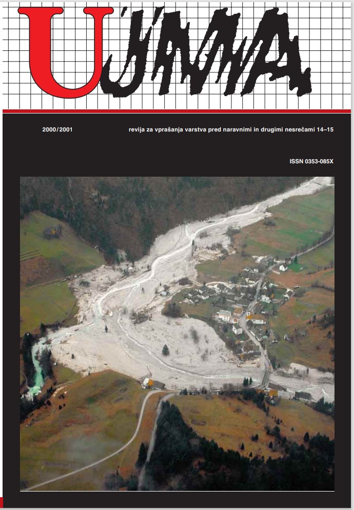
Abundant rainfall in the unusually warm month of November 2000 was the main cause of floods and landslides. The largest landslide struck the alpine village of Log pod Mangrtom. The second in size, in terms of volume of moving land masses, occurred in the area of Slano Blato above the village of Lokavec near Ajdovščina. The Slano Blato landslide above Lokavec near Ajdovščina covered (buried) approximately 15 hectares of forest and grassland. The landslide originated on a slope built of flysch rock, and was comprised mainly of crushed flysch rocks and clayey gravel. The landslide is a periodical phenomenon that is triggered approx. every 100 years. This contribution presents a brief record of a landslide that occurred at the end of the 19th century, followed by geological, hydrological, meteorological and other data on the recent Slano Blato landslide.
Downloads
References
Buser. S., 1973. Osnovna geološka karta SFRJ 1 : 100.000, List Gorica L 33 – 78. – Zvezni geološki zavod, Beograd.
Buser. S., 1973. Osnovna geološka karta SFRJ 1: 100.000, List Gorica L 33 – 78. Tolmač lista Gorica – Zvezni geološki zavod, Beograd.
Geoinženiring d.o.o., Dimičeva 14, Ljubljana: Poročilo o inženirskogeoloških razmerah na plazu Slano blato v obdobju med 23. 11. 00. in 20. 12. 00.
Kos, V., 1985. Atlas Slovenije. Mladinska knjiga, Geodetski zavod Slovenije
Peter Medvešček: Opis Sv. Križa, Gorica 1904.
Plesničar, P., 1997. Ajdovščina, Pogled v njeno preteklost (komentirana objava zgodovine Ajdovščine in Šturij). Pokrajinski arhiv Nova Gorica.
Downloads
Published
Issue
Section
License

This work is licensed under a Creative Commons Attribution-NonCommercial-NoDerivatives 4.0 International License.
The articles are made available to the public under Creative Commons Attribution-NonCommercial-NoDerivatives 4.0 International (CC BY-NC-ND 4.0).
